Rev. FCA UNCuyo | 2026 | 58(1) | ISSN 1853-8665
Economy and agricultural politics
https://doi.org/10.48162/rev.39.205
Determinants of Agricultural Land Prices in the Mendoza River Basin: A Spatial Hedonic Analysis with Emphasis on Irrigation Water
Determinantes del precio de la tierra agrícola en la Cuenca del Río Mendoza: un análisis hedónico espacial con énfasis en el agua de riego
Alejandro Juan Gennari 1,
María Eugenia Martinez Fagliano 1,
Patricia Lilian Winter 1,
Juan Matías Elissonde 2
1 Universidad Nacional de Cuyo. Facultad de Ciencias Agrarias. Cátedra de Economía y Política Agraria. Almirante Brown 500. M5528AHB. Chacras de Coria. Mendoza. Argentina.
2 Universidad Nacional de Cuyo.
* vciardullo@fca.uncu.edu.ar
Abstract
This research examines the determinants of agricultural land prices in the Mendoza River Basin, with emphasis on the marginal contribution of irrigation water as a strategic resource in an arid context. An original georeferenced database of 297 cultivated rural properties (2003-2024) was compiled, using advertised asking prices expressed in 2024 constant US dollars. A mixed spatial hedonic model with a log-log functional form was applied, incorporating hierarchical random effects (district nested within department), exponential spatial correlation, and heterogeneous variance across districts. The results indicate that properties with definitive surface irrigation rights command prices approximately 21% higher than comparable properties that rely exclusively on groundwater, confirming surface irrigation water as a pivotal economic asset. Soil quality and productive improvements increase land values by approximately 20% and 21%, respectively. In contrast, land size and distance to urban centres have significant negative effects (elasticities of -0.39 and -0.47). These findings highlight the central role of surface irrigation water as an economic asset and indicate a territorially segmented land market. The proposed methodology provides empirical evidence to support the design and implementation of water management and land-use planning policies in irrigated agricultural regions.
Keywords: hedonic pricing, farmland value, irrigation water, land characteristics, geostatistics, arid regions, river basins
Resumen
Esta investigación examina los determinantes del precio de la tierra agrícola en la Cuenca del Río Mendoza, con énfasis en la contribución marginal del agua de riego como recurso estratégico en un contexto árido. Se compiló una base de datos georreferenciada original de 297 propiedades rurales cultivadas (2003-2024), utilizando precios de oferta publicados expresados en dólares estadounidenses constantes de 2024. Se aplicó un modelo hedónico espacial mixto con forma funcional log-log, que incorpora efectos aleatorios jerárquicos (distrito anidado en departamento), correlación espacial exponencial y varianza heterogénea entre distritos. Los resultados indican que las propiedades con derechos definitivos de riego superficial presentan precios aproximadamente un 21% superiores a los de propiedades comparables que dependen exclusivamente de agua subterránea, lo que confirma al agua de riego superficial como un activo económico fundamental. La calidad del suelo y las mejoras productivas incrementan el valor de la tierra en aproximadamente un 20% y un 21%, respectivamente. En contraste, el tamaño del predio y la distancia a centros urbanos ejercen efectos negativos significativos (elasticidades de -0,39 y -0,47). Estos hallazgos subrayan el papel central del agua de riego superficial como activo económico y revelan la existencia de un mercado territorialmente segmentado. La metodología propuesta aporta evidencia empírica para apoyar el diseño e implementación de políticas de gestión del agua y de planificación del uso del suelo en regiones agrícolas irrigadas.
Palabras clave: precio hedónico, valor de la tierra agrícola, agua de riego, características del terreno, geoestadística, regiones áridas, cuencas hidrográficas
Originales: Recepción: 24/09/2025 - Aceptación: 16/12/2025
Introduction
Land valuation in irrigated arid regions is a complex and multidimensional process in which physical (soil quality, topography), productive (crop type, farm improvements and infrastructure), institutional (irrigation rights and reliability), and territorial factors (accessibility, proximity to urban centres) interact to actively shape prices (Caballer & Guadalajara, 2005). In such settings, water scarcity and supply variability are binding constraints that affect both expected agricultural productivity and the formation of land prices. The institutional architecture of irrigation -combining surface canals, wells, legal water rights, and conveyance efficiency- together with pronounced spatial heterogeneity in soil quality, productive specialization and accessibility, yields segmented markets in which territorial and water-related attributes translate into price differentials across farms (Caballer & Guadalajara, 2005).
These features are particularly pronounced in the Mendoza River Basin, the province’s main agricultural oasis. Urban expansion into peri-urban fringes, increasing fragmentation of farm structures, pressure on the availability and quality of irrigation water, and growing competition for land uses collectively shape market dynamics in which price signals reflect agricultural returns, locational services (access to roads and markets), climate risk (hail) and edaphic quality. The interplay between natural endowment (soils, water), capital investment (on-farm improvements, pressurized irrigation) and accessibility tends to reinforce intra-basin territorial gaps, making consistent quantitative evidence essential to guide water management and land-use planning.
These territorial dynamics are consistent with evidence from irrigated areas in the neighbouring San Martín Department, where declining irrigation water availability and irrigation management constraints have intensified land-use pressures and contributed to rural abandonment (Guida-Johnson et al., 2024).
Analytically, hedonic price theory posits that the price of a heterogeneous asset can be decomposed into the implicit values of its observable attributes (Rosen, 1974). Applied to farmland, the literature repeatedly documents positive effects of irrigation availability/ reliability, soil quality and productive infrastructure, alongside negative effects associated with distance to urban centres and, frequently, parcel size when the outcome is expressed as price per hectare (Chicoine, 1981; Decimavilla & Sperlich, 2008; Fraser & Hilder, 2007; Gracia et al., 2004; Huang et al., 2006; Palmquist & Danielson, 1989). Previous studies consistently report sizeable and robust irrigation premia across alternative functional forms: approximately 15-20% in Mediterranean land markets (Sardaro et al., 2020), around 29% for the adoption of drip irrigation systems (Donoso et al., 2013), and up to 63% in Spanish estimates (Caballer & Guadalajara, 2005).
Complementary evidence also reports implicit unit values for irrigation water, ranging from about USD 9-44 per acre-foot in the United States (Faux & Perry, 1999) to €3.46/m³ (capital value) and €0.14-0.35/m³ (rental value) in the Guadalquivir Basin (Berbel & Mesa, 2007), underscoring water’s role as an economic asset capitalised into agricultural land prices. In this context, high-value perennial crops (vineyards, fruit orchards) and on-farm improvements (including pressurized irrigation) tend to raise prices, whereas adverse environmental conditions (e.g., salinity) and greater remoteness from markets reduce them (Decimavilla & Sperlich, 2008; Fraser & Hilder, 2007; Gracia et al., 2004; Huang et al., 2006; Mukherjee & Schwabe, 2014).
A central methodological issue is the spatial dimension of land markets. In many irrigated environments, prices exhibit spatial autocorrelation and territorial heterogeneity (administrative hierarchies, irrigation associations and farmer-managed irrigation boards), violating independence and homoskedasticity assumptions in OLS and potentially biasing coefficients and standard errors (Guadalajara et al., 2019). Consequently, spatial specifications -spatial-lag and spatial-error models, mixed-effects structures, and log-log generalizations- are increasingly used to capture neighbourhood spillovers and improve fit and inference relative to OLS (Guadalajara et al., 2019; Huang et al, 2006; Mukherjee & Schwabe, 2014). In arid irrigated regions in particular, water quality -with emphasis on salinity and supply variability- emerges as a key price determinant and a source of omitted-variable bias if ignored (Mukherjee & Schwabe, 2014). Yet, most empirical evidence still comes from developed countries, and there is a dearth of studies integrating hedonic approaches with spatial econometrics for arid Latin American settings; recent work in Argentina advances mapping and prediction under different frameworks and aims (Córdoba et al., 2021).
Recent reviews reinforce this diagnosis. Ciardullo & Gennari (2025) indicate that previous studies highlight the importance of incorporating irrigation-water attributes, spatial dependence, and territorial heterogeneity into hedonic models, as these factors are regarded as relevant for explaining price formation in arid regions. Their review also identifies major methodological gaps in Argentine empirical research, particularly the limited valuation of irrigation water rights and the scarce integration of geostatistical and spatial-econometric tools into hedonic approaches. In this context, the development of spatially explicit models that quantify the contribution of irrigation water and other territorial attributes to land values in the Mendoza River Basin becomes especially relevant.
In sum, the state of the art indicates that (i) irrigation water -as a scarce environmental resource- has an implicit value systematically capitalised into farmland prices; (ii) soil quality and productive improvements increase value; (iii) accessibility (distance) and negative externalities reduce it; and (iv) spatial dependence and territorial heterogeneity must be modelled explicitly to obtain valid, policy-relevant elasticities and inferences (Caballer & Guadalajara, 2005; Guadalajara et al., 2019; Huang et al., 2006; Mukherjee & Schwabe, 2014; Rosen, 1974). Against this backdrop, the present article undertakes a spatial hedonic analysis based on a mixed log-log specification for the Mendoza River Basin, integrating water-related attributes (type of supply), productive features, and territorial factors, and quantifying the marginal effects and price differentials that characterise its segmented land market.
The general objective of this study is to analyse and quantify the determinants of agricultural land prices in the Mendoza River Basin, with particular emphasis on the marginal contribution of irrigation water in an arid irrigated setting, by estimating a spatial hedonic mixed log-log model that explicitly captures spatial dependence and territorial heterogeneity and yields policy-relevant elasticities and price differentials.
Hypotheses of the Study
Building on the theoretical expectations summarised above, the study advances the following central hypothesis:
H1. Properties with secure surface irrigation rights command higher land prices than otherwise comparable properties that rely exclusively on groundwater, reflecting the capitalisation of irrigation water as a scarce and strategic economic asset.
Materials and Methods
Study Area
The Mendoza River Basin, located in Mendoza, Argentina, is the most important irrigated system in the province, encompassing the departments of Las Heras (including its high-mountain area), Lavalle, Guaymallén, Maipú, Luján de Cuyo, parts of San Martín, and the urban areas of Capital and Godoy Cruz. The study area corresponds specifically to the agricultural production zones of the basin, supplied by both surface and groundwater resources, while excluding high-mountain environments and fully urbanised areas (figure 1). This agricultural territory exhibits pronounced heterogeneity in soil quality, irrigation infrastructure, and productive specialisation.
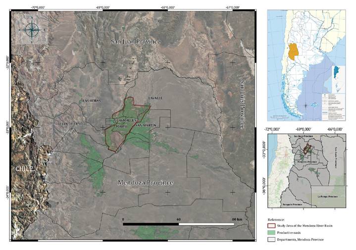
Author’s elaboration based on georeferenced data from the National Geographic Institute (IGN), Argentina. Source: National Geographic Institute (IGN) (2025). Environmental and Territorial Information System (SIAT). Google Satellte and Open Street Map.
Elaboración propia a partir de datos georreferenciados del Instituto Geográfico Nacional (IGN), Argentina. Fuente: Instituto Geográfico Nacional (IGN) (2025). Sistema de Información Ambiental y Territorial (SIAT). Google Satellite y OpenStreetMap.
Figure 1. Map of the Study Area in the Mendoza River Basin, Mendoza Province, Argentina.
Figura 1. Mapa del área de estudio en la Cuenca del Río Mendoza, Provincia de Mendoza, Argentina.
Vineyards predominate in Maipú and Luján de Cuyo -often complemented by enotourism and high-value agribusinesses- while Lavalle and Las Heras are characterised by more diversified cropping systems, including horticulture and forages. Spatial variability across the study area is shown in figure 2, which maps (a) asking farmland prices per hectare (constant 2024 USD, by range) and (b) irrigation water supply type.
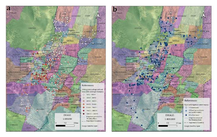
(a) Advertised asking prices per hectare (2024 constant USD, by range); (b) Irrigation water by supply type (surface, groundwater, mixed). Source: Our elaboration.
(a) Precios de oferta publicados por hectárea (USD constantes de 2024, por rango); (b) Agua de riego según tipo de abastecimiento (superficial, subterráneo, mixto). Fuente: Elaboración propia.
Figure 2. Cultivated Rural Properties in the Mendoza River Basin.
Figura 2. Propiedades rurales cultivadas en la Cuenca del Río Mendoza.
Database Construction
The dataset was constructed from advertised asking prices published in classified listings from major provincial newspapers and real estate portals (Inmoclick, Cocucci, Contacto, Argenprop) covering the period 2003-2024. For 2003-2013, data were reconstructed from the physical archive of Los Andes newspaper and collected using a systematic sampling strategy -the second and fourth Sundays of May, August, and November- to avoid seasonal distortions (e.g., harvest effects). For 2014-2024, the database was updated at five-year intervals (2018 and 2024), ensuring temporal coverage while maintaining consistency with the sampling framework.
A total of 297 cultivated rural properties were included. All advertised asking prices are standardised to constant 2024 US dollars using the U.S. CPI-U index (Bureau of Labor Statistics; data from the Federal Reserve Bank of Minneapolis). The study excludes parcels with evident peri-urban conversion potential to focus on agricultural land markets. Screening combined municipal zoning regulations, proximity to urban boundaries with public services, and explicit marketing language in the advertisements (e.g., “suitable for subdivision”, “residential estates”, “developments”, industrial/commercial, per-square-meter quotations, swimming pool, scenic views, detailed urban buildings).
The resulting dataset provides a cross-sectional sample of homogenised property values suitable for estimating static econometric models of farmland prices. Following Caballer and Guadalajara (2005), this approach responds to the structural limitation of low transaction frequency in rural land markets by constructing a single standardized reference period. Property prices are expressed in constant 2024 dollars, allowing the model to capture market values at a given moment in time. Accordingly, the econometric specification is formulated as a static cross-sectional model in spatial terms, under the assumption that temporal variables are fixed at a single value. This design enables robust estimation of the marginal contribution of attributes, particularly irrigation water, to agricultural land values. Building on this framework, the explanatory variables were organized into four groups, selected based on economic theory, prior hedonic evidence, and data availability.
Physical attributes included total farm area (hectares), a cultivated area index (share of the holding under cultivation), crop type (viticultural, fruit, or horticultural), productive improvements (buildings such as a farmhouse and/or shed, and productive facilities such as a packing house, greenhouse, or small-livestock unit), and water-supply type (surface, groundwater, or mixed). Territorial attributes comprised department and district, distance to the urban centre (Mendoza kilometre zero, km 0), soil quality by irrigation suitability from the Instituto Nacional de Tecnología Agropecuaria (INTA) (2025) in collaboration with the Departamento General de Irrigación (DGI, Government of Mendoza Province), hail risk from the Dirección de Contingencias Climáticas (DCC, Government of Mendoza Province), and surface-water quality from the Instituto Nacional del Agua (INA, Argentina). The economic context captured departmental gross regional product (GRP) from the Dirección de Estadísticas e Investigaciones Económicas (DEIE, Government of Mendoza Province); departmental billed revenue for 2024 varietal grape production -computed as the cash and financed average price weighted by output in quintals- and the departmental average varietal grape price, both compiled by the Bolsa de Comercio de Mendoza (BCM, 2024). Finally, the social context included population density (per km², 2022) and the population growth rate (2010-2022) from the Instituto Nacional de Estadísticas y Censos (INDEC, Argentina). See Table A.1 in Appendix for the complete list of variables.
Spatial Hedonic Model: Specification and Estimation
We estimated a spatial hedonic mixed (multilevel) model with a log-log functional form:
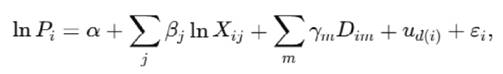
where
Pi = price per hectare (2024 USD) of property i
lnXij = continuous covariates in natural logs interpreted as elasticities
Dim = dummies are dummy variables, with percentage effects computed as 100[exp(γm)-1] ud(i) = random intercept for district d nested within department (ud∼N(0,σ2 u))
εi = residuals with exponential spatial correlation structure (corExp) based on inter-point distances in the project CRS.
To address heteroscedasticity, we incorporated a variance identity function (varIdent) that allows residual variance to differ by district. This specification corrects for systematic variability in error dispersion across territorial units, improving the reliability of estimated standard errors.
We fitted the models using the nlme package in R. Competing specifications of fixed effects, random structures, and correlation families were compared using maximum likelihood (ML) and information criteria (AIC/BIC). Final estimates and standard errors are reported under restricted maximum likelihood (REML), with 95% confidence intervals derived from Wald approximations using nlme’s degrees-of-freedom. Diagnostics included residual analysis, assessment of heteroscedasticity, and checks for residual spatial autocorrelation (Moran’s I).
Continuous regressors were log-transformed and then mean-centred (after logging) to preserve the elasticity interpretation of βj\beta_jβj and improve numerical stability; no standard deviation scaling was applied. Mean-centring shifts the intercept but does not affect slope coefficients, while SD scaling would alter the elasticity interpretation.
Modelling Strategy
We followed a three-step strategy to structure inference and robustness: i) Exploratory analysis and baseline OLS (m_lin); ii) Main specification (m0F1_log); iii) Alternative specifications.
- Exploratory analysis and baseline OLS (m_lin). Descriptive statistics and ANCOVA guided variable screening and coding. We then estimated an exploratory log-log OLS on the 297 constant-price observations to obtain a transparent baseline (elasticities/signs) and to inspect residual patterns.
- Main specification (m0F1_log). The preferred model is the mixed log-log spatial specification described above, with district random effects (nested in department), corExp residual correlation and varIdent heteroscedasticity. Model selection among random and correlation structures used ML; inference is reported under REML.
- Alternative specifications for robustness.
• A GAM (lnPi∼s(lnDist)+s(lnArea)+⋯)
• was estimated to assess potential non-linearities and check the stability of coefficient signs and significance.
• A model with Matérn residual correlation was fitted as an alternative to the exponential (corExp) structure to test sensitivity to the choice of spatial covariance family.
Model comparisons drew on adjusted R², explained deviance, and residual diagnostics. The spatial mixed model (m0F1_log) was ultimately retained for its combination of interpretability (elasticities) and superior overall fit.
Results
Descriptive Statistics and Preliminary Analysis
Descriptive statistics reveal marked territorial segmentation. Average land prices range from USD 8,620/ha in Lavalle (88 cases) to USD 27,526/ha in Maipú (101 cases). All property prices are expressed in constant 2024 US dollars. The complete table of descriptive statistics is provided in Appendix A2.
To examine the role of agricultural attributes, ANCOVA models were estimated to compare adjusted mean prices across crop types and irrigation water sources. Results show that crop type exerts a significant influence on market values (table 1): vineyards and fruit orchards command premiums of roughly USD 2,600/ha relative to horticultural land. Similarly, irrigation water access strongly differentiates land values (table 2): properties supplied with surface or mixed water achieve higher adjusted prices than those relying exclusively on groundwater.
Table 1. Comparison of adjusted mean prices by crop type (ANCOVA results, Fisher’s LSD, α = 0.05).
Tabla 1. Comparación de medias ajustadas de precios según tipo de cultivo (resultados de ANCOVA, LSD de Fisher, α = 0,05).
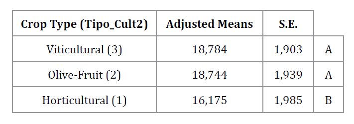
Means sharing a common letter are not significantly different (p > 0.05). Source: Own elaboration.
Las medias que comparten una misma letra no presentan diferencias estadísticamente significativas (p > 0,05). Fuente: Elaboración propia.
Table 2. Comparison of adjusted mean prices by type of irrigation water supply (ANCOVA results, Fisher’s LSD, α = 0.05).
Tabla 2. Comparación de medias ajustadas de precios según tipo de abastecimiento de agua de riego (resultados de ANCOVA, LSD de Fisher, α = 0,05).
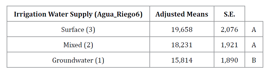
Means sharing a common letter are not significantly different (p > 0.05). Source: Own elaboration.
Las medias que comparten una misma letra no presentan diferencias estadísticamente significativas (p > 0,05). Fuente: Elaboración propia.
Exploratory OLS baseline (m_lin)
An exploratory log-log OLS model was estimated on the 297 constant-price observations (2024 USD). Predictors included quantitative covariates (log-transformed continuous variables, interpreted as elasticities) and categorical attributes (dummy indicators, interpreted as percentage premia relative to the reference category, 100[exp(β)-1]). The model attains adjusted R² = 0.524, with AIC = 541.80 and BIC = 567.89.
Results highlight the central role of irrigation water, crop type, and productive improvements. Properties supplied by surface or mixed irrigation command an estimated premium of about 27% relative to groundwater; permanent crops (viticulture or fruit orchards) are associated with a 22% premium compared to horticultural land; and buildings or productive facilities imply a 16% premium. Soil quality shows a positive but statistically insignificant effect (≈ +7%).
Continuous variables exhibit the expected negative elasticities: for distance to the urban centre (β = -0.445), a 10% increase reduces prices by ≈ 4.5%, and doubling distance lowers values by ≈ 26-27%. For farm size (β = -0.299), a 10% increase reduces prices by ≈ 3.0%, and doubling area lowers values by ≈ 18-19%. Departmental GRP has a small but positive and statistically significant effect (β = 0.037).
Taken together, these results confirm that access to irrigation water, permanent crops, and on-farm improvements are dominant price determinants, while larger and more distant farms are penalized in the land market. However, because this model does not account for spatial autocorrelation or hierarchical territorial structure, it motivated the transition to the spatial mixed-effects log–log model (m0F1_log), estimated on the same 297 cases.
Spatial Hedonic Mixed Model (m0F1_log)
The preferred specification is a multilevel spatial hedonic model (MLM) with a log-log functional form, estimated on the full sample of 297 properties. The estimated coefficients are presented in table 3. The final econometric specification (m0F1_log) includes district-level random effects and an exponential spatial correlation structure, and is expressed as follows:
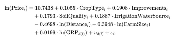
Table 3. Estimated coefficients of the spatial mixed log-log hedonic model (m0F1_log).
Tabla 3. Coeficientes estimados del modelo hedónico espacial mixto log-log (m0F1_log).
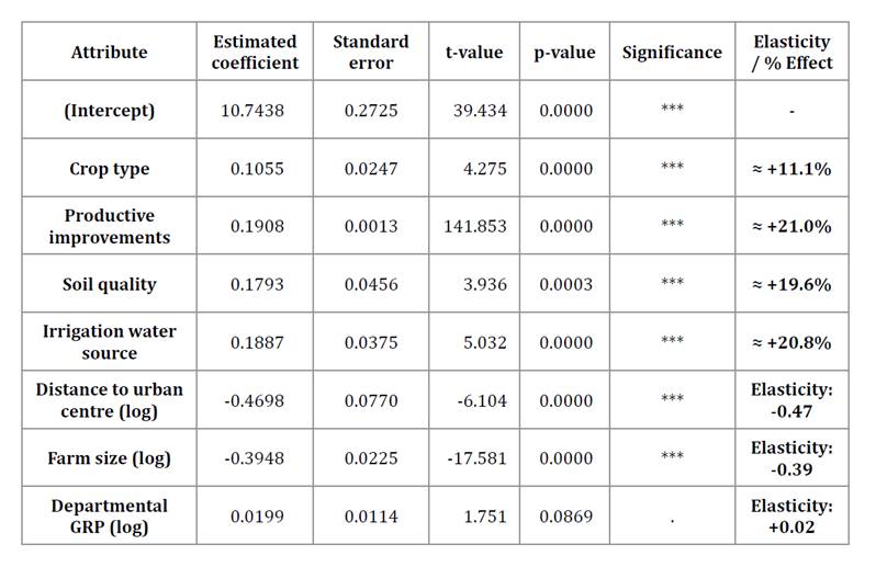
Significance / Significancia: *** p < 0.001; ** p < 0.01; * p < 0.05; . p < 0.1.
Properties supplied by surface or mixed irrigation command an estimated premium of ≈21%, equivalent to ≈USD 3,951/ha when evaluated at the sample mean price of USD 18,996/ha, relative to groundwater-dependent properties. Permanent crops (viticulture and fruit orchards) exhibit a premium of ≈11%, corresponding to ≈USD 2,108/ha, compared to horticultural land. Productive improvements (e.g., buildings and facilities) show the largest effect, increasing land values by ≈21%, or ≈USD 3,989/ha at the mean. Importantly, soil quality also emerges as a significant determinant once spatial dependence and hierarchical structure are modelled explicitly. While the baseline OLS specification (m_lin) suggests a positive but statistically insignificant effect, the spatial mixed model estimates a ≈20% premium (≈USD 3,723/ha) for properties with adequate soils. This contrast reflects the gains in efficiency and reduced bias achieved when accounting for spatial correlation and administrative hierarchy, factors that otherwise inflate residual variance and dampen significance in non-spatial models.
Continuous variables behave as expected. The elasticity for distance to the urban centre is -0.470, implying that a 10% increase in distance reduces land prices by about 4.7% (≈USD -893/ha), while doubling distance leads to a decline of ≈ 27-28% (≈USD -5,129/ha). Farm size elasticity is also negative (-0.395): a 10% increase in area reduces land prices by ≈ 3.9% (≈USD -746/ha), and doubling area lowers values by ≈ 19-20% (≈USD -3,799/ha). Departmental GRP has a small positive effect (0.020, significant at the 10% level), implying an increase of ≈2% (≈USD 380/ha) for a 10% rise in local economic activity.
Goodness-of-fit metrics confirm the adequacy of this specification (table 4). The model achieves a log-likelihood of -231.8, with AIC = 581.5 and BIC = 797.9. The random-effects structure captures territorial heterogeneity: the district-level random intercept shows meaningful variability (SD ≈ 0.192), while the department-within-district component is negligible. The exponential spatial correlation (corExp) presents an estimated range of 0.0274 and a small nugget effect (0.00205), indicating limited residual spatial dependence once fixed and random effects are accounted for.
Table 4. Goodness-of-fit metrics and model parameters for the spatial hedonic mixed model (m0F1_log).
Tabla 4. Medidas de bondad de ajuste y parámetros del modelo hedónico espacial mixto (m0F1_log).
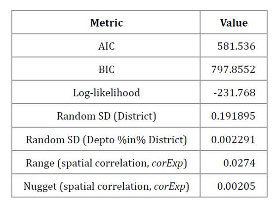
Source: Authors’ calculations using hierarchical linear mixed-effects modelling (lme) in R.
Cálculos de los autores utilizando modelos lineales mixtos jerárquicos (lme) en R.
Residual diagnostics further support model adequacy. The scatterplot of predicted values against studentized residuals shows no systematic patterns, confirming homoscedasticity. Similarly, the normal Q-Q plot indicates approximate normality of residuals, with only minor deviations in the tails. These diagnostics (figure 3) strengthen confidence in the reliability of the model’s inference.
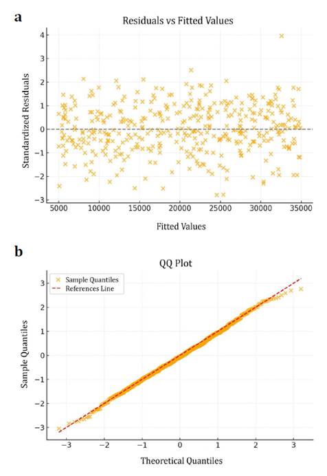
(a) scatterplot of predicted values vs. Studentized residuals, (b) normal Q-Q plot of residuals. Source: Own elaboration.
(a) diagrama de dispersión de valores predichos vs. residuos estudentizados, (b) gráfico Q-Q normal de los residuos. Fuente: Elaboración propia.
Figure 3. Residual diagnostic plots for the spatial mixed log-log model (m0F1_log).
Figura 3. Gráficos de diagnóstico de residuos para el modelo hedónico espacial mixto log-log (m0F1_log).
Taken together, these findings demonstrate that irrigation water, crop type, soil quality, and productive improvements are the strongest determinants of farmland values in the Mendoza River Basin, while larger and more distant farms are systematically penalized. The inclusion of hierarchical random effects and spatial correlation provides a more robust inference framework than non-spatial alternatives, supporting the reliability of the spatial mixed log-log model (m0F1_log).
Predictive Validation
The predictive performance of the preferred spatial mixed model (m0F1_log) was assessed using two cross-validation schemes: random 5-fold and spatial leave-onecluster- out (k-means, k=5). In the random cross-validation, the model achieved RMSE = 14.18 USD (±1.97) and MAE = 10.03 USD (±1.33), both below the observed standard deviation of land prices (17,230 USD/ha). These error metrics are computed in the log-price estimation scale, consistent with the log-log specification of the model and therefore serve as relative indicators of predictive performance rather than absolute monetary errors. In the spatial cross-validation, which is more demanding as training and test sets come from different geographic clusters, the model attained RMSE = 13.87 USD (±6.58) and MAE = 9.74 USD (±4.45).
In both cases, predictive errors were substantially lower than the overall price dispersion, confirming that the model significantly reduces uncertainty compared to a naïve mean-based estimator. The slightly superior performance under spatial validation suggests robust generalization to unobserved geographic areas, attributable to the inclusion of spatial correlation (exponential structure) and hierarchical random effects (district/department).
Residual Diagnostics and Spatial Autocorrelation
Residual diagnostics indicate that the model adequately accounts for spatial dependence. Moran’s I test on normalized residuals (k = 8 nearest neighbours) yielded a statistic close to zero (I = -0.014, p = 0.66), showing no significant spatial autocorrelation. This confirms that the spatial correlation and hierarchical effects embedded in m0F1_log successfully captured the underlying spatial structure of farmland prices.
Additional graphical checks -including the Moran’s I, Moran Scatterplot, LISA maps, and the empirical semivariogram- also showed no residual spatial patterns, reinforcing the robustness of the specification. Together, these results validate both the predictive capacity and the spatial adequacy of the model, supporting its use for territorial applications and policy analysis. Full results are reported in Appendix: Moran’s I test (Table A.3), LISA cluster map and Moran scatterplot (Figure A.1a and A.1b) and residual semivariograms (Figure A.2a and A.2b).
Comparative Analysis with Alternative Models
Two sets of comparative results are presented to evaluate alternative hedonic specifications.
First, table 5 reports the explanatory performance of the models in terms of adjusted R² and explained deviance. The results highlight the improvement from the baseline OLS (m_lin) to the spatial GAM and finally to the mixed spatial log- log model (m0F1_log), which attains the highest explanatory power (>99% deviance explained) while preserving interpretability in terms of elasticities.
Table 5. Comparative performance of hedonic models by functional form and explanatory power.
Tabla 5. Comparación de modelos hedónicos según la forma funcional y el desempeño explicativo.
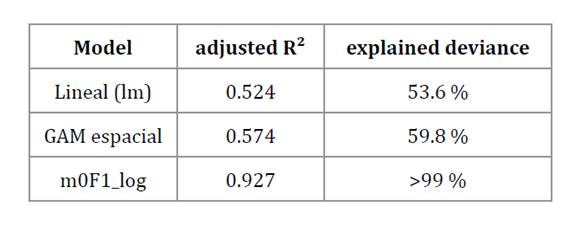
Source: Authors’ elaboration based on a dataset of 297 properties (2024 constant USD).
Elaboración de los autores sobre la base de un conjunto de datos de 297 propiedades (USD constantes de 2024).
Second, table 6, provides a more comprehensive comparison of specifications and diagnostics across alternative hedonic models. This extended summary includes the baseline OLS, intermediate mixed-effects models, the final spatial mixed log-log model, and robustness checks with GAM and Matérn specifications. The comparison highlights both methodological differences and empirical performance, justifying the selection of m0F1_log as the preferred specification.
Table 6. Comprehensive comparison of spatial hedonic models: specifications and diagnostics.
Tabla 6. Comparación integral de modelos hedónicos espaciales: especificaciones y diagnósticos.
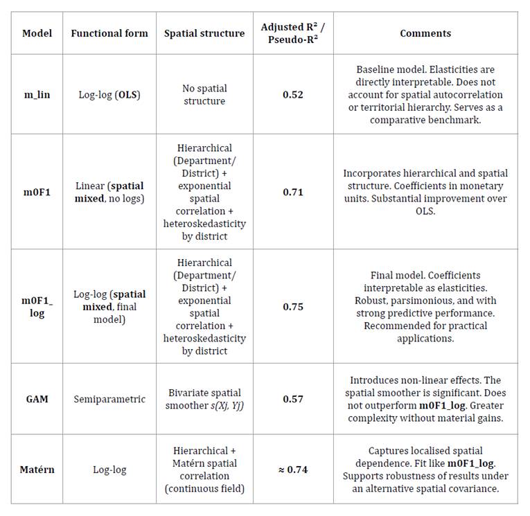
Source: Authors’ elaboration based on a dataset of 297 properties (2024 constant USD).
Elaboración de los autores sobre la base de un conjunto de datos de 297 propiedades (USD constantes de 2024).
In summary, the comparative evidence confirms that although both the GAM and Matérn specifications yield consistent results, the spatial mixed log-log model (m0F1_log) remains the preferred specification. It combines robust performance, parsimony, and superior explanatory power, while retaining the advantage of directly interpretable elasticities, making it the most suitable model for applied analysis of agricultural land values.
Discussion
The analysis confirms that farmland values in the Mendoza River Basin arise from the combination of water, productive, territorial, and socioeconomic attributes, in line with hedonic theory and previous empirical evidence. The estimated elasticities and percentage impacts provide a transparent assessment of the relative importance of each factor, offering insights that are both statistically rigorous and territorially relevant. These results support the study’s central hypothesis that secure access to surface irrigation water is capitalised into agricultural land prices.
Irrigation Water as a Key Economic Attribute
One of the most robust findings concerns irrigation water. Properties supplied by surface or mixed sources command a price premium of approximately 21% relative to those relying exclusively on groundwater -an effect that amounts to roughly USD 3,951/ha at the sample mean. This result emphasises the critical role of water availability, quality, and security of supply in determining land values, especially in semi- arid regions such as western Argentina, where agricultural productivity fundamentally depends on water availability.
The finding is consistent with international evidence reporting positive capitalization of irrigation water rights into land values (Mallios et al., 2009; Demetriou, 2015; Palmquist & Danielson, 1989).
Crop Type and Market Segmentation
Crop type is another key determinant. Permanent crops -viticulture, olive groves, and fruit orchards- are valued more highly than horticultural land, reflecting an ≈11% premium (≈USD 2,108/ha). This premium aligns with the long-term profitability and market stability associated with perennial crops, which are often integrated into high-value agribusiness and enotourism chains. The capitalization of crop type into land values confirms prior findings in Mediterranean and Latin American agricultural markets (Huang et al., 2006; Palmquist & Danielson, 1989), where perennial systems systematically capture higher implicit rents.
Productive Improvements and Infrastructure
Infrastructure also plays a decisive role. Properties with productive improvements –such as buildings or productive facilities- exhibit premiums of around 21% (≈USD 3,989/ha). These results indicate that the market values not only the physical assets but also their capacity to lower entry barriers and enable immediate productive use. This interpretation is consistent with evidence from other Argentine regions (Marcolini Tulliani, 2015), where infrastructure is understood as an asset that signals future profitability and reduces investment uncertainty.
Soil Quality and Agronomic Suitability
Soil quality, often neglected in market analyses, plays a decisive role. Properties with soils of adequate to marginal suitability (classes 2-3) are valued around 20% higher (≈USD 3,723/ha) than those with poor soils (class 4). Although soil quality was not statistically significant in the non-spatial OLS model, its significance in the spatial specification reflects the efficiency gains from incorporating hierarchical random effects and spatial correlation. This result reinforces the need to integrate edaphic indicators into valuation and land-use planning, consistent with evidence from Huang et al. (2006).
Farm Size and Scale Effects
Farm size exhibits the expected inverse relationship with land value. The negative elasticity (β = -0.395) shows that larger holdings receive systematically lower per-hectare prices: a 10% increase in size reduces land values by approximately 3.9%, while doubling farm size leads to a decline of around 19-20%. This pattern reflects economies of scale and weaker market demand for large properties, consistent with international evidence (Bastian et al., 2002; Maddison, 2000).
Distance and the Urban Gradient
Accessibility strongly influences land values. Distance to Mendoza city displays a negative elasticity (β = -0.470): a 10% increase in distance lowers land prices by approximately 4.7%, while doubling distance leads to a decline of around 27-28%. This finding accords with Von Thünen’s classical rent theory (1826/1966) and corroborates recent spatial studies highlighting the importance of accessibility to services, infrastructure, and markets in shaping agricultural land values.
Socioeconomic Context: Departmental GRP
Departmental GRP exerts a small but positive influence on land values. Although the effect is only marginally significant at the 10% level (p = 0.10), its positive sign is consistent with the expectation that more economically dynamic territories tend to command higher agricultural land values. While not definitive, this pattern reinforces the interpretation of land markets as embedded within broader territorial development dynamics (Greene, 2011; Gujarati, 2003).
Geostatistical Modeling and Spatial Patterns
The spatial mixed model (m0F1_log) shows no significant global spatial autocorrelation in the residuals (Moran’s I, p > 0.05), indicating that the principal determinants operate relatively uniformly across the study area. Accordingly, geostatistical interpolation methods such as ordinary kriging or regression kriging were not applied, as these techniques require spatial dependence in the residual structure. Even so, descriptive maps reveal marked inter-departmental price differences -higher in Maipú and Luján de Cuyo and lower in Lavalle- likely reflecting contrasts in irrigation infrastructure, market access, and agroecological conditions.
Cross-validation results further demonstrate the model’s predictive strength. RMSE values of approximately 14 in the log-price estimation scale remain far below the observed price dispersion (standard deviation ≈17,230 USD/ha), evidencing substantial gains in predictive accuracy relative to a naïve benchmark. Both random and spatial validation schemes produce consistent results, underscoring the robustness of the specification and its suitability for applied land-market analysis in arid irrigated regions.
Conclusions
This study provides new empirical evidence on the determinants of agricultural land values in the Mendoza River Basin by integrating hedonic spatial econometrics with geostatistical validation. The results show that irrigation water, crop type, productive improvements, and soil quality are the dominant drivers of land values, while larger and more remote farms are systematically penalised. The strong premiums associated with perennial crops, productive improvements, and especially surface or mixed irrigation water emphasise the strategic importance of these attributes in arid agricultural systems. These results are consistent with the study’s central hypothesis, demonstrating that secure access to surface irrigation water is a key determinant of land values in arid contexts.
Methodologically, the findings demonstrate the importance of modelling spatial correlation and hierarchical structure. Soil quality, which was not statistically significant in a non-spatial OLS framework, became significant once spatial dependence was accounted for, illustrating the risks of biased or inefficient inference in models that ignore spatial processes. This reinforces the relevance of spatial econometric approaches for land-valuation research in heterogeneous and water-scarce regions.
From a policy perspective, the study highlights the close connection between land values and secure access to irrigation water, along with investments in permanent crops and infrastructure. These insights are particularly relevant for territorial planning, water allocation, and agricultural investment decisions in semi-arid environments where water is a binding constraint.
The spatial mixed log–log model (m0F1_log) achieved robust explanatory and predictive performance, providing a reliable framework for the economic valuation of agricultural land in water-scarce contexts. By combining econometric rigour with spatial realism, the study contributes to both the scientific literature and the design of evidence-based land and water policies in arid regions.
Future research could compare land prices between properties with and without access to irrigation water to better inform water governance and territorial development.
Bastian, C. T., McLeod, D. M., Germino, M. J., Reiners, W. A. & Blasko, B. J. (2002). Environmental amenities and agricultural land values: A hedonic model using geographic information systems data. Ecological Economics, 40(3), 337-349. https://doi.org/10.1016/S0921-8009(01)00278-6
Berbel, J., & Mesa, P. (2007). Valoración del agua de riego por el método de precios quasi-hedónicos: aplicación al Guadalquivir. Economía Agraria y Recursos Naturales, 7(14), 127-144.
Bolsa de Comercio de Mendoza. (2024). Estadística de los Mercados-Uva varietal. https://bcmdz.com.ar/servicios/tasa-estadistica#mercados
Caballer Mellado, V., & Guadalajara Olmeda, N. (2005). Modelos econométricos de valoración de la tierra de uso agrícola: Una aplicación al Estado español. Revista española de Estudios Agrosociales y Pesqueros, 205, 13-38.
Chicoine, D. L. (1981). Farmland values at the urban fringe: An analysis of sale prices. American Journal of Agricultural Economics, 63(3), 530–537.
Ciardullo, V. F., & Gennari, A. J. (2025). Agricultural Land Valuation-Hedonic Pricing and Geostatistical Advances: A State-of-the-Art Review. Revista de la Facultad de Ciencias Agrarias. Universidad Nacional de Cuyo. 57(2), 224-236. https://doi.org/10.48162/rev.39.185
Córdoba, M., Carranza, J. P., Piumetto, M., Monzani, F., & Balzarini, M. (2021). A spatially based quantile regression forest model for mapping rural land values. Journal of Environmental Management, 289, 112509.
Decimavilla, E., & Sperlich, S. (2008). Urban pressure and land value in Spain: A hedonic pricing approach. Agricultural Economics Review, 9(1), 22-33.
Demetriou, D. (2015). A GIS-based hedonic price model for agricultural land. In D. G. Hadjimitsis, K. Themistocleous, S. Michaelides, & G. Papadavid (Eds.), Proceedings of SPIE. The International Society for Optical Engineering, 9535, 95350B. https://doi. org/10.1117/12.2192498
Departamento General de Irrigación. (2016). Balance Hídrico Río Mendoza. DGI.
Departamento General de Irrigación, Mekorot Israel National Water Co., & Consejo Federal de Inversiones. (2023). Plan Maestro para el sector hídrico de la provincia de Mendoza: Informe 1. Estudio de la situación actual del sector hídrico. https://www.irrigacion.gov.ar/web/wp-content/uploads/2025/03/1-PLAN-MAESTRO-PARA-EL-SECTOR-H%C3%8DDRICOInforme-1-MENDOZA.pdf
Dirección de Agricultura y Contingencias Climáticas. Gobierno de Mendoza. (2010). Índice de siniestralidad por granizo. https://www.mendoza.gov.ar/contingencias/
Dirección de Estadísticas e Investigaciones Económicas. Ministerio de Gobierno, Infraestructura y Desarrollo Territorial. Gobierno de Mendoza. (2024). Participación del Producto Bruto Geográfico por Departamento. https://deie.mendoza.gov.ar/
Donoso, G., Cancino, J., & Foster, W. (2013). Farmland values and agricultural growth: The case of Chile. Economía Agraria y Recursos Naturales, 13(2), 33-52. https://doi.org/10.7201/earn.2013.02.02
Faux, J., & Perry, G. M. (1999). Estimating irrigation water value using hedonic price analysis: A case study in Malheur County, Oregon. Land Economics, 75(3), 440-452.
Federal Reserve Bank of Minneapolis. (2024). Consumer Price Index, 1913. https://www.minneapolisfed.org/about-us/monetary-policy/inflation-calculator
Fraser, I., & Hilder, C. (2007). Vineyard capitalisation: A hedonic analysis of wine grape growing properties. Australian Journal of Agricultural and Resource Economics, 51(1), 1-17.
Gracia, A., Pérez y Pérez, L., Sanjuán, A., & Barreiro Hurle, J. (2004). Análisis hedónico de los precios de la tierra en la provincia de Zaragoza. Estudios Agrosociales y Pesqueros, 202, 51-69.
Greene, W. H. (2011). Econometric Analysis (7th ed.). Pearson. (Note: the 7th edition was published in the United States in 2011, and in its international version in 2012; the content is identical.).
Guadalajara, H., García, L., & Rodríguez, J. (2019). Assessing the localization impact on land values: A spatial hedonic study. Spanish Journal of Agricultural Research, 17(3), e0110. https://doi.org/10.5424/sjar/2019173-14961
Guida-Johnson, B.; Vignoni, A. P.; Migale, G. M.; Aranda, M. A.; Magnano, A. (2024). Rural abandonment and its drivers in an irrigated area of Mendoza (Argentina). Revista de la Facultad de Ciencias Agrarias. Universidad Nacional de Cuyo. 56(1): 35-47. DOI: https://doi.org/10.48162/rev.39.121
Gujarati, D. N. (2003). Basic econometrics (4th ed.). McGraw-Hill.
Huang, H., Miller, G., Sherrick, B., Gómez, M. (2006). Factors influencing Illinois farmland values. American Journal of Agricultural Economics, 88(2), 458-470.
Instituto Geográfico Nacional. Información geoespacial. (2025). Capas SIG. https://www.ign.gob.ar/NuestrasActividades/InformacionGeoespacial/CapasSIG
Instituto Nacional de Tecnología Agropecuaria & Departamento General de Irrigación. Gobierno de Mendoza. (2025). Clasificación de suelos y aptitud de riego de la Provincia de Mendoza.
Maddison, D. J. (2000). A hedonic analysis of agricultural land prices in England and Wales. European Review of Agricultural Economics, 27(4), 519-532. https://doi.org/10.1093/erae/27.4.519
Mallios, Z., Papageorgiou, A., Latinopoulos, D., & Latinopoulos, P. (2009). Spatial hedonic pricing models for the valuation of irrigation water. Global NEST Journal, 11(4), 575-582.
Marcolini Tulliani, S. B., Verón Medina, C. S., & Goytia García, M. D. (2015). Rentabilidad y precio de la tierra agrícola: un estudio sobre la región pampeana argentina. CAPIC Review, 13(1), 21-30.
Mukherjee, M., & Schwabe, K. A. (2014). Where’s the salt? A spatial hedonic analysis of the value of groundwater to irrigated agriculture. Agricultural Water Management, 145, 110-122.
Palmquist, R. B., & Danielson, L. E. (1989). A hedonic study of the effects of erosion control and drainage on farmland values. American Journal of Agricultural Economics, 71(1), 55-62.
Rosen, S. (1974). Hedonic prices and implicit markets: Product differentiation in pure competition. Journal of Political Economy, 82(1), 34-55. https://doi.org/10.1086/260169
Sardaro, R., La Sala, P., & Roselli, L. (2020). Land pricing in rural development: The role of irrigation and territorial policies. Land Use Policy, 94, 104531
von Thünen, J. H. (1966). Isolated state: An English edition of Der isolierte Staat. (P. Hall, Ed. & Trans.). Pergamon Press. (Original work published 1826).
https://drive.google.com/file/d/1V77HtChvbDmympq9GpUh8CFouaV6Oxl6/view?usp=drive_link